SouthBayStreets – Introduction to Maps
© 2025 McQuillin & Associates Inc. -- Company Confidential
Guide Ver 0.8 – 2025-04-14 – For South Bay Streets Ver 0.8 – R. McQuillin
1. NOTE: ROUGH DRAFT / WORK IN PROGRESS: This guide may be updated often. Please note the version number above. A version history is in Appendix A.
2. NOTE: This document is COMPANY CONFIDENTIAL with limited distribution. It has been provided to you for early review. Please do not forward, copy, or otherwise distribute it without prior authorization.
Contents
3 What is South Bay Streets (Streets)?
4 What are SeeArtesia and SeeTheGalleria?
5.3 Scenarios for Business Connections
5.4 Scenarios for City Planning
5.5 Why Not Just Use Google Maps?
5.6 Other Similar Maps (Mall Maps, Visitor Maps)
5.7 PUTTING IT ALL TOGETHER: VISUAL STOREFRONT DIRECTORIES, PLUS MORE
8 Using the Maps – How To’s (A Quick Guide)
8.1 How to … Find a MapSet or Map
8.4 How to … Search for a business or business type.
8.6 How to … Review Location information
8.8 How to … Move from Map to Map
10 Appendix A: Version History
12 Appendix C: Frequently Asked Questions
1 Introduction
SouthBayStreets (“Streets”) is a web application that provides community commerce. The first phase provides maps that are visual storefront directories for communities. This document is for people who want to know what the Streets maps are all about and to use the basic map capabilities.
2 Our Need for Community
In brief, we all need community for our personal health, social health, the health of our neighborhoods, and the life of our city. One type of community is local commerce: shoppers meeting with merchants, local workers, possibly family members, experts, supporters, and each other. We do this to purchase efficiently and with satisfaction and joy to meet our needs and achieve our goals for home, health, family, friendships, occupation – all aspects of life.
SouthBayStreets hopes to address one aspect of this need by providing community commerce. Right now, online shopping is increasing and moving us away from the local, physical community we need. We aim to tilt the financial and psychic equation back from online shopping to local shopping. We’ll do this with a new approach. These maps are a first step in this direction. More will follow soon.
3 What is South Bay Streets (Streets)?
South Bay Streets (a.k.a. “SBS” or just “Streets”) is a web application that will improve commerce in the South Bay of California. It will do this by linking customers with businesses in ongoing, fulfilling relationships.
The first phase of Streets is simple commerce Maps. These maps let customers (residents and visitors) explore and understand what’s in their commerce community (malls, shopping centers, corridors, streets, popups, fairs, etc.). They are visual storefront directories for communities.
You can use maps as a guest (without an account) or as a member. This document describes what you can do as a guest. Members can do much more. The Streets Maps User Guide describes what you can do with a member account.
4 What are SeeArtesia and SeeTheGalleria?
The SeeArtesia.com and SeeTheGalleria.com links take you to the first two maps provided by Streets. They are commerce maps for two pilot locations in north Redondo Beach, California. These two high commerce locations in a great city are experiencing challenges: traffic and sales are low. The Streets app aims to improve this situation, creating a better experience for everyone: residents, visitors, businesses, and the city.
5 Why Use Streets?
Streets maps provide a business-focused (or purpose-focused) view of commerce areas for consumers. They are meant to help customers “get things done”.
5.1 Who Are Streets Maps For?
Residents & locals. See what's in your neighborhood, within walking distance.
Commuters. What are you passing by each day and missing? Make some stops!
Home and apartment seekers. Thinking about moving? Want to know what's here?
Visitors and tourists. Want to take a walk through the area? It's great for meetups, too.
Prospective tenants. Want to decide whether to open a business here?
Planners. Want to decide if a proposed business will work well here?
5.2 Scenarios for Discovery!
Here are some scenarios why/when you’d want to open the map for a street you’re on or nearby:
You’re driving through. What am I missing that I should stop for?
You’re visiting a restaurant. When you’re done, what’s around here?
You’re staying at a hotel. What can I see and do around here?
You’re thinking of moving here. What’s here?
You’re getting your car fixed. What’s here, while I wait?
You’re waiting for your child to finish class. What can I do?
5.3 Scenarios for Business Connections
You’re scouting a location to decide whether to open a business.
You’re opening a business nearby, and you want to find all complimentary businesses.
You’re doing local sales on foot.
You want to offer a bulk service to stores in the neighborhood.
5.4 Scenarios for City Planning
You’re deciding what businesses will work well in an area.
The Maps provide a unique summarized and condensed view of businesses in a locale.
City planners will have other resources, but they may find they can use these maps to determine how a business will fit in.
To help, residents can also use the maps see what’s “missing” and request businesses. We will provide this information to prospective businesses.
5.5 Why Not Just Use Google Maps?
Great question! Google Maps are nice and powerful, with many features Streets maps don’t have. But Streets maps serve a different purpose. Streets maps aren’t even really “maps”. They are storefront directories that are laid out in the order you’ll see the stores when you visit.
Google maps are MAPS. Streets maps are business DIRECTORIES organized by location.
Streets maps are made for residents and visitors:
(1) To discover and learn about commerce and activity in a specific area now, and
(2) To have efficient visits with map in hand (on cell phone).
So, Streets maps have a bundle of advantages over the more common online maps. Here’s a comparison with Google maps:
· The Streets maps are all business, and only businesses, packed together for fast access. There are no homes, warehouses, gaps, farms, factories, fields, golf courses, etc. Only places where you might walk in and do something. They are normally for B2C use (business-to-consumer), but some support B2B (business-to-business) if you actually visit that site to do business. It’s just easier to find a business on a Streets map. On Google maps, there’s a lot of info on the screen that you don’t need.
· Google maps are geographical. In a sense, Google maps are a prisoner of geography. Streets maps aren’t geographical, they are compact and flexible and they can change based on what you need.
· The Streets maps contain all businesses, not just those registered with Google.
· The Streets maps are up to date and accurate. They are maintained locally.
· Streets maps show businesses outside (streets) and businesses inside (malls).
· Streets maps show temporary businesses and commerce areas, on the same maps when useful:
o Fairs and events.
o Seasonal sales.
o Maker’s marts.
o Popup sales. And you can show popups ‘interspersed’ with local businesses.
o Sidewalk sales.
These maps are quick and easy to set up, change, share, and remove when finished (or hide away until the next event).
o (Coming soon) You’ll be alerted when anything changes.
o (Coming soon) Locations will also be linked to sellers, for the full commerce experience. Even temporary vendors may form longer-term relationships after the event is over.
· Google maps aren’t very good for discovery. Basically, you need to know what you’re looking for. If you don’t, Google maps don’t tell you a lot, are hard to navigate, and may leave out a lot of interesting locations. Most businesses aren’t shown on the overhead maps. Streets maps let you discover:
o You can see the totals of businesses by type and click to see only those businesses on the map (with all others hidden) for quick access.
o You can scroll through the businesses – just like walking down and around the block on your phone -- and discover what you didn’t expect, or sometimes exactly what you needed.
o You can use the pre-searched options, like:
§ Food and drink (quickly see just the restaurants)
§ Uncommon or one-of-a-kind businesses
§ Kid’s places
§ Fashion shops
§ Available properties
· You can click to quickly move from one compact map to another using the map links.
· Streets maps are owned and managed by local community members. We will keep Streets updated much better than Google. Frankly, we’ve seen Google still list sites that closed two years ago. That’s not helpful and can create headaches and a big waste of your time.
· You can create Fantasy maps. You can create a personal map that bundles all your merchants together. This will be much more valuable during phase 2 when we link you with your merchants.
· You can create Island maps. Island maps can collect up all the small clusters of businesses around a city so they are easier to find all in one place.
· Just so you know, in Streets there are no online reviews of the businesses. Go see them for yourself! That’s the point. But you can always click through to Google and see Yelp, etc.
· Finally, Google is constrained by being Google. By their own greatness and bigness. Google maps are always geographical. Google must cover the world. We don’t have to. And frankly, Google maps are clumsy for many uses. Google doesn’t have anybody here to help you. We do. We are neighbors with a love for and commitment to our community.
· And that’s just the basic Phase 1 Maps. Soon you’ll be able to customize your maps: add visit plans, connect with merchants, and fulfill your needs. When you’re signed in, you have a whole new level of capability:
o Create your own maps to use yourself and/or share with others.
o Bundle maps into map sets
o {Coming) Connect with merchants in maps to streamline a visit to a map.
You can use Google maps to navigate to your destination, then use Streets maps to move around once you get there.
So, use Google maps for what Google maps are great for, and use Streets maps to know your commerce community and get your things done!
(CORRELLARY June 1, 2025: Google maps might even be getting less useful. I just searched for “men’s hair” near me, and it recommended about ten places. The top listings were over two miles away, and the three barbers and stylists in my neighborhood weren’t in the list.)
5.6 Other Similar Maps (Mall Maps, Visitor Maps)
To further put Streets maps in context, here are some other “similars”:
Mall Maps. Malls (shopping centers) usually have maps, or directories. Streets maps have a lot in common with mall maps: they are compact and store-focused. So, you could think of Streets maps as mall maps for streets, fairs, etc. but more capable. Mall maps are usually stylized and harder to read and use. So, you could think of Streets maps as mall maps, but for everywhere, and for quick use.
Visitor Maps. Tourist destinations often have visitor maps so you can see what’s available. But they are limited to the visitor area, and ‘static’ (they don’t really do anything). And they are hard to keep up to date.
Event Maps. Like visitor maps, events often have maps, and they usually have the same limits as visitor maps.
5.7 PUTTING IT ALL TOGETHER: VISUAL STOREFRONT DIRECTORIES, PLUS MORE
You could think of Streets maps as all of these rolled into one, but better: mall maps combined with visitor maps, for everywhere, inside, outside, temporary, permanent, but compact, flexible, much more powerful, and up to date.
Another way to think of Streets maps: they are visual storefront directories. That itself can be useful.
But these maps are just the first component of community commerce. The maps will be the directories into our new commerce communities. Streets maps are live! Use them to live your life!
6 MapSets
A map set is just a collection of maps. Here are some possible map sets:
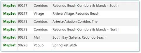
There are two types of map sets: Shared and Personal. Here are some samples:
6.1 Shared Map Sets
These are generally useful. These are created by owners and shared for general use:
1. Maps for a city.
2. Maps for a zip code.
3. Maps for a village.
4. Maps of a mall / shopping center.
Map Sets can also be temporary, for an event or fair or popup, for example.
6.2 Personal Map Sets
With an account, you can create map sets to collect maps the way you want to see them and use them. For example. You might collect the maps for these reasons:
1. For your commute to/from work.
2. For a road trip.
3. For a shopping trip.
4. For all the places you like to shop (your ‘favorites’)
(Coming soon) You can also share personal map sets, for collaboration with your friends, advisors, personal shoppers, etc.
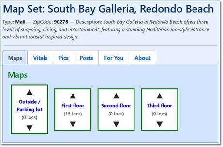
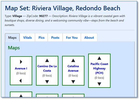
7 Maps
Each map always has one main street or ‘spinal’ street that runs down the center of the map.
Streets maps are “first-person overhead”, as if you are standing in the spinal street and looking down from the top of the screen. So, you can scroll down the page to walk down the street, viewing the businesses on each side.
The things on the sides of the street are called ‘locations’. They are usually addresses with businesses in them, but they may also be streets, easements, etc. There may be locations with more than one business.
Sometimes you can peek down a side street to see businesses there.
If there’s a link on a street, you can click to jump to that map. You can always come back.
8 Using the Maps – How To’s (A Quick Guide)
Maps are also Shared or Personal, just like map sets.
Guests can use the pre-created shared map sets and maps. The simple “How To’s” for basic maps are listed below.
(Members can sign in to create and share maps and perform many more functions. See the Streets Maps User Guide for those “How To’s”.)
8.1 How to … Find a MapSet or Map
1. From the SouthBayStreets.com home page, click the All Maps link.
2. Locate the map set or map you want to use by name or zip code.
3. If it’s a map set, you’ll see the Maps tab. Click on the map you want to use.
8.2 How to … Understand a Map
When you enter a map, you’ll be on the Map tab, viewing the map itself.
· Click on the Vitals tab to see summaries and other statistics about the map.
· Click on the Pics tab to see any pictures.
· Click on the About tab to see more information about the map.
· (Coming) Click on the Posts tab to see News, Alerts, Sales, Events, etc.
· (Coming) Click on the For You tab to go to your tie-ins with the map: offers for you, news for you, your planned visits, etc.
NOTE:
· A map set has the same tabs as a map. For a map set, any data is ‘totalled up’ for all the maps in the set. For example, the Vitals data and the Posts are ‘totalled up’ for all maps in the map set.
8.3 How to … Browse a Map
(See the general “Maps” section above.)
8.4 How to … Search for a business or business type.
Click on “Find a Business” to specify what you’re looking for. You can search for a business by name, type, tag, keyword. The map will be ‘filtered’ and shrunk to show just the business(es) you searched for. The streets will still be there so you can see how to get there.
8.5 How to … Save a Bookmark
The Streets pages are “deep-linkable”. That is, when you perform a search and find what you’re looking for, you can save that page as a bookmark and return to it. You can also share that link with someone else in a text, email, DM, etc.
8.6 How to … Review Location information
Click on any location name to view details about that location, including:
1. The Occupant.
2. The Location.
3. The Owner.
8.7 How to … Jump to Google
The location details page has contact and other useful information about the business. If you want more, you can jump to Google. Usually that will take you to the Google summary page for the business and to the Google map with the business on it.
8.8 How to … Move from Map to Map
If a street on a map (a cross-street or tee-street) shows a map name, you can click on the name to move to the major street on that map.
9 Future Plans
We hope you will find the maps useful and fun to use by themselves. But they are just the ’tip of the iceberg.’ Community commerce is coming. We’ll be providing more information soon.
10 Appendix A: Version History
|
Version |
Date |
Primary Author |
Change Summary |
|
0.8 |
2025-04-14 |
R.McQuillin |
Original |
|
|
|
|
|
11 Appendix B: Terms Used
Some quick terms:
· “SouthBayStreets”, “Streets”, and “SBS” all mean the same thing: this web application.
· TBD, TBP, TBS, $FINISH$, or $IMPROVE$ are markers for an unfinished part of this document. You shouldn’t see those, but it you do, we’re working on it!
12 Appendix C: Frequently Asked Questions
(None yet)